Friday, April 14, 2006

talk20: Instant Replay

Well, if you came out to talk20 last night – thanks! It was great.


I figured if any attendees were looking for more info about the things that came up, I should do a quick – though almost absurdly link-intensive – summary here... which may or may not be useful.
So: here's the abandoned island off Japan that both Herman Mao and I talked about – including this amazing gallery of black and white photography.
The Helicopter Archipelago, then, designed with Leah Beeferman, takes flight here – where you'll also find information about the Maunsell Towers


– which were extensively explored and written up by the lads at Underground Kent.
Those tectonic maps of North America are by Ron Blakey. His timeline of paleogeographic evolution makes the brain reel.
Meanwhile, Geoff Shearcroft's mouse with a house on its back


– can be gazed upon lovingly here; Mr. Shearcroft is co-founder of the Agents of Change, a London-based architecture firm also responsible for these projects. And if you're into the genetically modified architecture thing – as explored by Ferda Kolatan last night, with his carrots – you might like these cloned motorways.
That self-unfolding house was by Andrew Maynard. Click around and see what else he's done – or read this interview with him, on Archinect.
Here are the silver blimp hotels, the water-drop printer (blasting Hitchcock films over Niagara Falls), the shadow billboard, and the gigantic, circular storm cells.
And... the food landscapes, of course, which were featured earlier on BLDGBLOG here and here.
Then there were the unstoppable, sewer-boating nutters of International Urban Glow – apparently run by a guy called Siologen. More info, and images, can be found here and especially here, that latter link being a personal favorite of mine – and an excuse to mention my novel, which is partially set in such subterranean locations. If you like all things underground, meanwhile, check out Sleepy City; the subterranean bunker cities of middle England; and Japan's secret sub-Tokyo of tunnels – the latter post having been plagiarized, along with several other BLDGBLOG posts – even BLDGBLOG's tagline – by a guy in Dubai.


If you liked the David Maisel images – and they're hard to dislike – check out this lengthy interview with him on Archinect. David's own website is totally amazing, however, so be sure to stop by – then lobby your local museum to host his current shows.
There were also the Bangladeshi shipbreaking yards, including some speculation about how to dismantle Gothic cathedrals, football stadiums, etc., on the beaches of equatorial archipelagos. The photos were by the terrifically great Edward Burtynsky.
And I didn't talk about this, but I should have: extruding cathedrals directly from the earth using magma from volcanic vents.
Finally, the J.G. Ballard material, about a flooded London, can be found here, where you'll discover "a nightmare world of competing organic forms returning rapidly to their Paleozoic past." The images, below, are by Bernhard Edmaier.


More J.G. Ballard here. And, speaking of London: what would its foundations sound like if you could listen to the city through headphones?
There was also James Bond: how to weaponize plate tectonics – with Grace Jones in tow.
After the event, I talked to a guy who was reading Suketu Mehta's Maximum City, a book which pops up in this post. And if you're still looking for more – which you probably aren't, frankly – there's this post, which acts as a nearly exhaustive, and certainly exhausting, narrative table of contents for BLDGBLOG. Have fun, keep in touch, see you next time – and a huge thanks to Alejandro and Benjamin for setting it all up. And to Detlef, who apparently supplied the wine and who keeps the ideas flowing – thanks!

Thursday, April 13, 2006

Avant-botany


[Image: Pruned takes us through the unearthly, spectrally backlit botanical studies of Jim Haseloff, University of Cambridge – glowing landscapes as only Pruned could find. This is the aterrestrial weirdness of Xylaria].

The Helicopter Archipelago

[Image: Leah Beeferman/BLDGBLOG, The Helicopter Archipelago, a flying micronation/airborne utopia; from an article by Geoff Manaugh originally published in Blend].

In 1964, Ron Herron of Archigram proposed a Walking City: urbanism gone ambulatory, a metropolis on the move. The Walking City, strutting along on iron stilts, was imagined as an “escape hatch from environmental conditions,” Simon Sadler writes. It was an “architecture of rescue” – a city in shining armor – “partly inspired by the tents and field hospitals of humanitarian relief efforts."

[Image: Ron Herron/Archigram, The Walking City].

Herron also had openly utopian intentions for the project. If the city didn’t like where it was, for instance – if its residents found their surroundings boring, oppressive or even quasi-fascist – the whole thing could simply stand up and walk away, re-settling itself elsewhere, freed from the constraints of law and geography.
But what if you didn’t live in the Walking City – indeed in any city at all? What good would it do you then?
For those of us trapped in a cultural desert, Archigram had another solution: the Instant City, flown in by hot-air balloon and helicopter and deposited anywhere in the world. The roofs, domes and canopies of a new metropolis could earn an official post-code in the blink of an eye.
There is no reason, however, to limit those helicopters to a role as mere delivery vehicles. The helicopters themselves could be liberated to form their own city – an airborne utopia, endlessly aloft, wandering through the planetary atmosphere. A helitopia, perhaps.
They could form, in other words, a helicopter archipelago, or flying island-chain, a brand new player in the sphere of geopolitics.

[Image: Leah Beeferman/BLDGBLOG, close-up of The Helicopter Archipelago].

Running on solar power, the helicopters would stay perpetually airborne – even as new machines latch on with rope ladders, the shape of the archipelago changing as its population expands. Pilots and passengers both could move between “islands” on bridges and zip-lines, which rearrange as the choppers switch position, moving in and out of formation.
All repairs would take place mid-flight.
A kind of flying Hawaii, or anti-gravitational Micronesia, with tanned deck-hands leaping across aerodynamic tailfins to the soundtrack of ceaseless enginery, the helicopter archipelago would act as an escape hatch from traditional, nation-state sovereignty. Its government would be a parliament of pilots, led by experts in storms, whose access to climatological data – future weather, air speed, barometric pressure – would determine the nation’s route and direction.
Never leaving the international airspace of unregulated trade winds, the archipelago would be impossible to map. Atlas-makers and manufacturers of globes will simply include a pack of removable stickers, featuring small clouds of helicopters, to approximate the country’s location…
Of course, these helicopters would not be the first manmade archipelago.
Today in Dubai, for instance, private hoteliers are developing both “The World” and “The Palm,” two artificial island chains of robotically-displaced sand upon which hotels and housing are being constructed.

[Image: Photographer unknown; creating an archipelago in Dubai. (Via Pruned)].

As the global oil economy begins to run dry, Dubai hopes to market itself as a tourist destination par excellence, boasting 7-star resorts –

[Image: The Palm (Via Pruned)].

– and an underwater hotel, where guests will look out through glass walls at schools of exotic fish.
Dubai supplies an interesting model, here, because if the helicopter archipelago ever found itself in need of a few extra – dollars? euros? pounds? – it could simply open itself up as a fantasy hotel. When the pressure of living terrestrially becomes too much, Tom Cruise and Katie Holmes could raise their kids there.
But if a flying resort of 7-star helicopters is too bourgeois for you, another manmade island chain worth considering is the aesthetic ancestor of Archigram’s Walking City: England’s Maunsell Towers. Built by the British Army during WWII, and named after their architect, Guy Maunsell, the Maunsell Towers were an offshore military fortress from which Army gunners could shoot down Nazi aircraft en route to bomb London.

[Image: Photographer unknown; the Maunsell Towers – for more information see Underground Kent].

Now rusting and derelict, the Towers have become eccentric tourist stops – yet the Maunsell Towers are just one example of offshore structures put to new use.
Sealand, for instance, is a self-declared country, constituted and run on a former anti-aircraft platform in the North Sea; today, it remains economically active as a data haven and pirate radio station, and it even issues passports – for which it has earned the status of micronation.

[Image: ©Ryan Lackey, Sealand].

So could the helicopter archipelago itself become a micronation? If so, how would it support itself, nutritionally or otherwise?
Could it have a seat at the U.N., or join the E.U., perhaps even train an Olympic team?
There might be flying gardens, for instance, bulging hammocks of soil cultivated to bear fruit. Almond trees, apiaries, chicken coops. A flying aquarium, with cloned fish suspended in pools above the Gulf Stream. An arts center, hospital and gymnasium.
The archipelago could issue stamps –

[Image: Leah Beeferman/BLDGBLOG, postage stamp for the Helicopter Archipelago].

– produce a permanent flag –

[Image: Leah Beeferman/BLDGBLOG, flag for the Helicopter Archipelago].

– and compose folk songs. Babies born onboard will be declared instant citizens, and the archipelago will welcome immigrants, incorporating whole new helicopter clusters at a time.
Once the archipelago is aloft for more than a century, the International Geological Society will declare it a flying continent, the world’s first airborne tectonic plate.
Some speculate that two million years from now the archipelago’s ruins will still hover in the sky: a ghostly blur across the north Atlantic horizon…

[Image: Leah Beeferman/BLDGBLOG, The Helicopter Archipelago; from the original article by Geoff Manaugh, published in Blend].

(Note: Leah Beeferman, who illustrated the "Helicopter Archipelago," is a Brooklyn-based artist and the graphic designer for Cabinet Magazine. [Cabinet, in fact, has a whole issue on micronations, if you're curious]. Leah's work has appeared on BLDGBLOG once before. Meanwhile, Lonely Planet is getting into the spirit with their forthcoming Lonely Planet Guide to Micronations, co-written by none other than Simon Sellars of Ballardian.com).

Wednesday, April 12, 2006

Solar geometries


[Images: More goodness from the wizard of pinholes, Nicolai Grossman, taken off his Spacetime set – click each image for original page. Is it possible for time itself to seizure? For temporality to get Tourette's? Is there a disease of the optic nerve in which moments echo – and would people sign-up for infection? Bruce Mau once wrote that tourists of the future will take "Disease Tours (complete with guaranteed cure)," riding bodily malfunction to a predictable end – but what do diseases of the eye look like from inside? More importantly: what if you built a house that actually looked like that?].

(See also The overlap and The blur, both with photos by Grossman).

The Clone Road


A few months ago, Pruned ran an excellent piece about farms for cloned meat. There, inside huge barns, rubbery mats of cloned muscle – stretched lumps of unBeef® – would vibrate, growing, pulsing, often ripping, beneath a steady stream of jelly-like vitamin wash. Nutrients would slide across those gleaming, fat-marbled surfaces... clumped and soapy.
A handful of underpaid Mexican night-workers would then come through with industrial strength pizza cutters, chopping the meat-sheets into rectangular blocks.
You would then buy one of those blocks, intending for your own kids to chew it and swallow it. This would be called "feeding them steak."
"Chicken."
"Pork."


But what really interests me here is whether such a scenario might pose a new future for landscape design.
What if someone were to develop, for instance, a kind of organic bio-paving for the world's freeways, replacing asphalt? In which case: could you clone whole stretches of interstate? Cloverleaf junctions, skyways, off-ramps?
Would summer road crews perform something more akin to skin-graft operations? Stretching huge films of living matter over the world's dual carriageways. Minimal surfaces.
And so on.


[Image: Frei Otto's architecture of minimal surfaces].

The risk, of course, would be that there's some fatal, unknown flaw in your cloning technique and so, one day, the freeways wake up. They shake themselves free from the dirt and filth; they tuck their herniated loops of distant traffic circles up underneath themselves; and they walk away...


All of LA's sprawling anatomy of freeways and cloverleaf junctions arises with a tectonic shiver from the arid sands of southern California, artificially intelligent, blinking with traffic lights, and it wanders free into the American desert. Shining. A kind of moving, hyperdimensional squid made of asphalt and miswired traffic control programs shambling into the mountains, raining cars.

Your Hidden City: Results

A while back, Tropolism announced Your Hidden City, an urban photography contest. Now, more than one thousand photographs later, the results are in...
Instead of one overall winner, however, each juror will be posting his or her favorites, allowing for different standards, tastes, opinions, etc. So, as one of those jurors, I chose... the following:
My personal favorite was this laundromat in Honolulu, which comes in under the category of "Best Hidden Place":


That would make an absolutely killer book cover, for instance.
For "Best Natural/Urban Overlap," I chose this one:


For "Best Vantage Point," I went with the bean by sgoralnick:


For "Best Density," I chose another photo by sgoralnick (I really like this one):


And, for "Best Building," I chose this mausoleum-like horror movie grid/void, aka the Université Henri Poincaré in Nancy, France, photographed by a good-looking Norwegian man:


C'est tout. It was fun. Maybe we can keep this going, do a seasonal thing...
Actually, here's a runner-up for "Best Hidden Place": hevy, for his/her documentation of Miami's Ballardian back-side, of which this is just one example:


Thanks, everyone – and congrats – and check out the other jurors' picks, too: architechnophilia, Miss Representation, Polis, Life Without Buildings, and, of course, el tropolismo himself.

Tuesday, April 11, 2006

Assembling North America


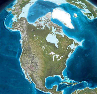
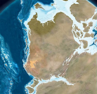
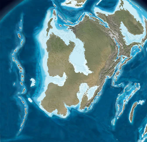
[Image: The present tectonic structure of North America, mapped by Ron Blakey, Professor of Geology, Northern Arizona University].

While out in California last month, hiking through Death Valley – on a cloudy day it looked like a painting by Caspar David Friedrich: an earth of snow, not salt flats – I read that California is actually a welded-together mass of remnant archipelagos and former island arcs.
In other words, down there in the Californian gravel are the buried edges of old island chains – and the whole state is still shivering with collision, making adjustments, popping loose and sticking, always on the move... then stopping.
Much is made of the apparent poetry of driving over the San Andreas Fault, which divides California into a left-half and a right-half, a coastal zone and a continental shield; but what of the silent lines you walk across everyday, from one former island to the next, unaware that those lands had even once been separated?
Midway through the trip, I picked up a copy of John McPhee's Assembling California, in which he describes residual structures of ancient geology with "no known bottom" because they cut so deep. He talks about "the metamorphosed remains of what had once been an island arc," and how, through constant collision and restlessness, entire "Newfoundlands, Madagascars, New Zealands, Sumatras, [and] Japans" have all jostled together, ramming one into the other, year after year, piling up, forming "the outermost laminations of new landscapes."
This is "the docking of arc and continent," a mismatched mess of rock "now consolidated as California."
"California," then, is just the temporary shape taken by these lost islands and unknotted seafloors.
Of course, then I found these unbelievable maps by Ron Blakey last week and I almost passed out. Utterly ingenious, each map represents "the paleogeography of North America over the last 550 million years of geologic history." You can actually watch as California comes home to collide.


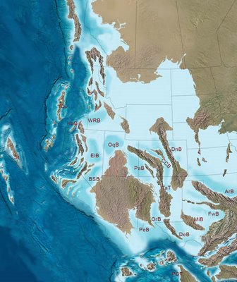
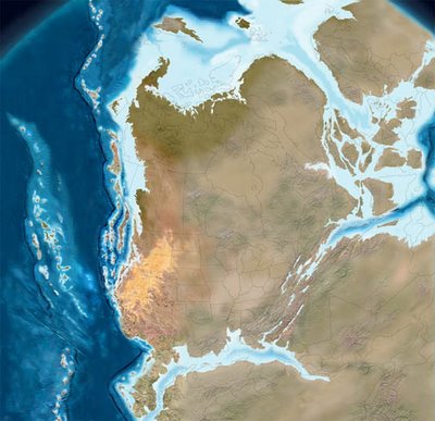
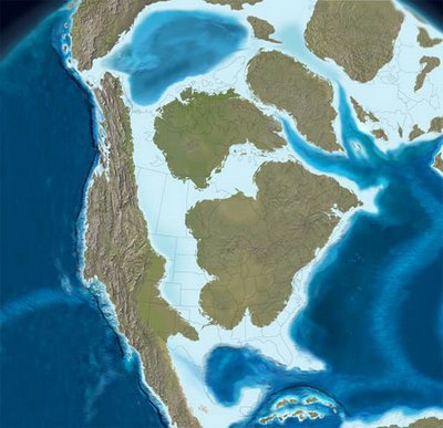
[Image: The southwestern coastal archipelagos of North America, 310 million years ago; map by Ron Blakey].

But let's pull back and start 420 million years ago (bypassing some 130 million years' worth of Blakey's maps).
This is North America, a tropical archipelago, covered in surreal vegetation, blowing seeds across itself – Shelley's "thousand nameless plants sown by the wandering winds" – cross-pollinating, hybridizing, surrounded by shallow seas, chugging northward over the equator.


75 million years later (below), what will eventually be North America has broken into pieces, partially flooded, surrounded by clusters of islands. These scattered subcontinents are about to collide with the north by northwestern edge of Africa – and unbelievable arcs, inlets, atolls, and bays all stretch across the landscape.
What was it like to live in that geography? What sounds did the forests make? What did the stars look like? What half-legged fish swam through those waters?


Another 50 million years pass, and the collision with Africa is well underway. Deserts are forming in the American southwest. Global wind patterns shift due to the distribution of landmasses.
Weird species that only live for a million years, and leave no fossil record, run unimpeded across giant landscapes of exposed bedrock.


Then the Atlantic rift begins; the Appalachian Mountains, which passed through Morocco, are now split onto three continents: North America, north Africa, and the embryonic British Isles, which drift northward, cultivating Albionic energy in ancestral swells of warm sea. William Blake will be born there – and Shelley, who'll write of a time "when St. Paul's and Westminster Abbey shall stand, shapeless and nameless ruins, in the midst of an unpeopled marsh."


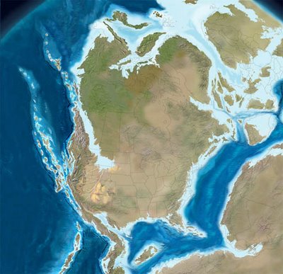
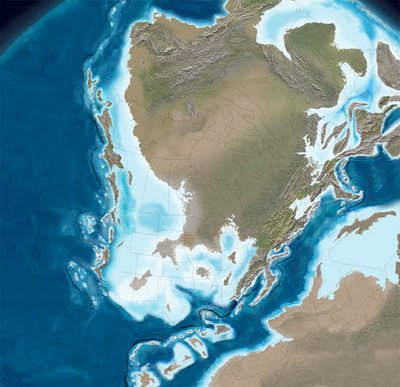
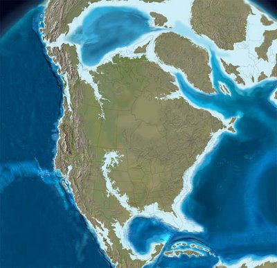
150 million years ago. California is already starting to form: it's a distant horizon of islands in the Pacific. Those mountains of rock above water are coming in toward the mainland, slowly, lurching forward on broken faults, a conveyor belt moving masses east to raise hills in a ring around Los Angeles, propelling the Sierra Nevadas upward, walling-in the great Arizonan desert now temporarily beneath the sea.
Could you map today's California according to the island chains it used to be?
And look at Mexico: it's a weird spit of land, hooked and crooked through the oceans, collecting islands onto itself. What would it have been like, walking through those coastal mountains? And if you carved an entire island to look like the cathedral of Notre-Dame, what would it look like, breaking waves, coming toward you over ten million years, eventually colliding with the cliffs you stand on?


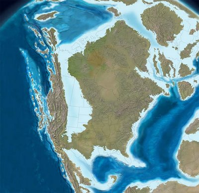
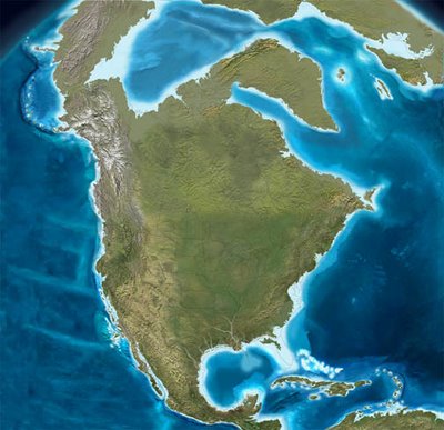
What's amazing in the above two images is that, in only 40 million years, an entire system of archipelagos has rammed into the mainland, assembling what will eventually become known as California, tipping the Rockies, torquing belts of metal into metamorphosed ribbons today exposed by roadcuts.
What must that time period have been like? With thousands of small islands – a whole Indonesia – off the coast, groaning at night with tectonic pressure, shattering from strain, causing landslides, you could have boated from bay to bay, mapping species, collecting rocks – knowing that beneath your feet is what will someday be Bakersfield, Santa Barbara, Death Valley.
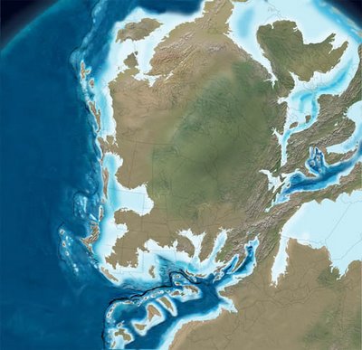
But now, in the map below, look at Mexico again: it's a broken ridge of almost-islands, cooking in the Cretaceous sun. The Yucatan is an island. The whole Pacific coast is a weather-beaten cliff of caves and pockets.
This was 65 million years ago.


Now the North American inland sea has sealed up, and a riverine bay several orders of magnitude larger than the Mississippi or the Saint Lawrence flows southeast across Texas.
Then it, too, is gone (below), leaving behind the massive fossil reefs of the Guadalupe Mountains National Park. There is no Florida yet; Alaska and Russia are one; the Caribbean is a malarial bog of proto-islands, choked with seaweed, overrun with electric eels and tide pools.
Somewhere humans are chipping flints together and hallucinating spaceships.


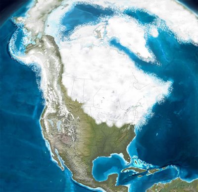
Till North America hits its Ice Age. Thousands of acres of frozen arches stand whistling in frigid winds above the future site of Washington DC. Humans huddle in caves – then move south, populating the New Mexican desert. Global sealevels drop, revealing caverns in the coasts of every continent.
The magnetosphere howls in the freezing air.


Then it's today. New oceans continue to form. Major geological events continue to happen. Someday the coast of California will drag along the edge of Alaska, depositing pieces of Culver City in the front range.
Eventually the planet will melt, cities forming rivers of liquid stone.
It's interesting in this context to note that, if the Antarctic ice cap melts, Antarctica itself may rise: "The continental shelf of the South Polar land lies four times lower than normal," New Scientist reported, "suggesting that if the ice (more than a mile thick below sea level at some points) were removed, the continental surface would rise." This is called post-glacial rebound.
Fascinatingly, Antarctica's "present mountains would attain considerable heights and introduce new frictional opposition to prevailing winds, so new weather patterns would be created."
In any case, every one of those maps above suggests about six hundred novels or short stories just waiting to be written; but the most exciting part of all of it is that we are already living in that world, of altered weather and island arcs, abraded coasts and rivers. It's what we're doing right now.
Beneath the house I write this in are seams of lost continents. Outside the place you read this in are moving unmapped geographies yet to come.

(Note: All maps in this post are by Ron Blakey, Professor of Geology, Northern Arizona University – perhaps, if enough people ask, we can get him to map North America as it will someday be).