Thursday, August 31, 2006

Ratcliffe Power Station

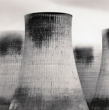
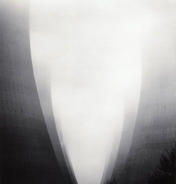
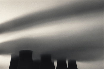
[Images: The archetypically geo-monolithic cooling towers of Ratcliffe Power Station, Nottinghamshire, England, photographed by Michael Kenna (©). Don't miss Kenna's recent work, including these spectacular photographs of Hokkaido – then go buy his 20-year retrospective. Earlier: Nuclear ambition].

Wednesday, August 30, 2006

Beijing Orbital

[Image: "The northernmost, barren reaches" of Beijing's 6th Ring Road. From Wikipedia].

In a recent interview with Ballardian.com, British author Iain Sinclair mentions that he hopes to begin a project called Beijing Orbital:
    When I was in Stavangar in Norway at one of these strange conferences, I saw a presentation by an assistant of Rem Koolhaas which was about the China TV building he’d built. He showed this virtual version of a city with seven orbital motorways just spreading out from the centre of this very traditional city into the desert, and the incredible pieces that were going up. I thought my god, it will be amazing to travel around these seven orbital motorways. Of course, that is relatively attractive to be made into a film. I think it will be reasonably possible to get a commission for that, which may also become a book. It will also involve me doing a lot of other things – circling round China as to what China means to different places in Europe, in the sense of Fu Manchu or people being drowned in Morecombe, all these stories, before I even embark on a journey to the place itself.
Maybe BLDGBLOG will beat him to it. Interested funders be in touch.

Nuclear Ambition

New Scientist reports that the cooling towers of nuclear power plants "could be evolutionary hotspots for new respiratory diseases."
It's architecture as a stimulus for Darwinian novelty.

[Image: Didcot power station; from Wikipedia].

The "warm, wet conditions" inside the towers have been found to host "several previously unknown strains of bacteria, including some that were similar to Legionella pneumophila, the cause of legionnaires' disease." The scientist behind this discovery warns that cooling towers are thus a source of pathogenic "aerosols" – invisible germ-clouds blowing out from their architectural origins to infect the lungs of animals nearby.
This nuclear landscape of concrete hyperboloids belching steam, and virulent microbes, into the sky should therefore "be monitored for emerging pathogens." Super-germs. Radioactive pneumonia.
Sci-fi novelists, heads up: a new plot beckons.

The U.S. Army Permafrost Tunnel

Between 1963 and 1965, the U.S Army Permafrost Tunnel was dug "entirely within frozen ground on the north slope of Hill 456 near Fox, Alaska."

Ice_Intrusion_155_ft_deep"Initial research" at the site "focused on developing new mining and tunneling methods for building underground facilities and foundations in permafrost. Special emphasis was given to tunnel behavior in permafrost, including deformation, natural air flow, feasible types of ventilation and thermal regime."

The tunnel is now maintained by the U.S. Army Corps of Engineers' Cold Regions Research and Engineering Laboratory – whose work "includes an amazing array of topic areas, including engineering and technology in cold regions, seismic-acoustic physics, tools for military combat and survival in cold weather, and many others."

If you're hoping to explore the place in person, however, beware that the tunnel's structure "requires a freezer unit" in order to survive the Alaskan summer – lest the whole place spontaneously liquify...
Meanwhile, soon to be discovered: a whole city of post-military ice caves, carved throughout the Alaskan peninsula and populated entirely by sightless humanoids – who are victims of an Army gene experiment gone awry.
Starring Samuel L. Jackson as a hot-headed spelunker who discovers his own father living nude in the deepest tunnel. "Enough is enough!" Jackson yells. "I have had it with my motherfuckin' father living in this motherfuckin' cave!"

Monday, August 28, 2006

Dwelling in an age of aeromodernism

lrg_roof_airportIn an old (1938) issue of Modern Mechanix, we read how an unnamed "French engineer" once proposed, "as a solution to the problem of locating an airport in the heart of any big city, a design for a long orientable runway, which would be mounted on circular tracks atop tall buildings." This megalithic, concrete, aerospatial earth machine would "orient" itself along specific air routes, hurling planes aloft over the rooftops of the city.

Though Modern Mechanix tags the idea with both "aviation" and "impractical," clearly the editors have not read this fascinatingly absurd, and much less practical, conspiracy theory about Denver International Airport.

"What on earth is going on at Denver International Airport?" the website asks. "Or should we be asking what is going on UNDERGROUND there?" According to the conspiracist's own "guerrilla" reportage:
    • The Queen of England has reportedly been buying up property in Colorado under a proxy.
    • There is a lot of "secret society" symbology at the airport, an AWFUL lot in fact
    • The symbolism apparent in the layout of the new Denver airport, some feel, says that it may be a control center for world control
And so on. Apparently some of the airport's murals are a bit dodgy – and that can only mean one thing... An AWFUL lot of one thing, in fact.

In any case, another (much more fascinating) article about urban airports of the future came out last month in Fast Company. There we read about the "rise of the aerotropolis":
    In the relatively obscure world of urban planning, [John] Kasarda, a professor at the University of North Carolina's Kenan-Flagler Business School, has made a name for himself over the past decade with his radical (some might say bone-chilling) vision of the future: Rather than banish airports to the edges of cities and then do our best to avoid them, he argues, we should move them to the center and build our cities around them.
ISS013-E-19323_lrg[Image: The neolithic geometry of Dallas-Fort Worth International Airport, a future archaeological complex which "occupies more surface area than the entire island of Manhattan." Image courtesy of NASA's Earth Observatory].

Kasarda points out that an "invisible plexus of air-cargo networks" allows globalization to function. This is space as re-defined by corporate proximity, international accessibility, and cargo transport logistics:
    Over the past 30 years, Kasarda will tell you, global GDP has risen 154%, and the value of world trade has grown 355%. But the value of air cargo has climbed an astonishing 1,395%. Today, 40% of the total economic value of all goods produced in the world, barely comprising 1% of the total weight, is shipped by air (and that goes for more than 50% of total U.S. exports, which are valued at $554 billion). Raw materials and bulkier stuff still take the slow boats, but virtually everything we associate with our postindustrial, value-added economy – microelectronics, pharmaceuticals, medical devices, Louis Vuitton handbags, sushi-grade tuna – travels via jumbo jet. We may think of the 1960s as the jet-set era, but the supremacy of (soft) airpower has only now begun to reshape our ideas about how cities should look, how they should function.
On the other hand, no mention of climate change – let alone air pollution, or the rising cost of jet fuel – is to be found.

Instead, we read, Hong Kong is now "premising its entire world-trade strategy on the primacy of the airport." Indeed, there is already "a mini-city stationed on a nearby island for [the airport's] 45,000 workers" – not to mention SkyCity, "a complex of office towers, convention centers, and hotels" for visiting CEOs and their consultant-class co-travelers.

In Beijing, "construction has begun on Beijing Capital Airport City, a $12 billion master-planned city of 400,000, and a massive airport expansion is coming to the city of Guangzhou, in the Pearl River Delta. Thirty-three miles to the south of Seoul, New Songdo City, billed as the most ambitious privately financed project in history, is taking shape in the Yellow Sea: The metropolis of 350,000 people, many of them expatriates living and working on-site for multinationals, is being built on a man-made peninsula the size of Boston."

[Images: New Songdo City; courtesy Kohn Pederson Fox. New Songdo City was covered a long time ago on BLDGBLOG at the very end of this post].

Dubai, Frankfurt, Amsterdam, Suvarnabhumi – the latter an airport-city in Thailand "slated to become a self-contained province governed by the prime minister himself" – everywhere, we're led to believe, will soon turn in to an aerotropolis. It is the next phase of urban anthropological history.

This new land use model, after all, is where we will find the "hotels, merchandise marts, [and] convention centers," the "free-trade zones, factories, warehouses, and logistics hubs," the "giant clusters of apartment towers and bungalows," within which expat middle managers and their armies of business process consultants will both work and dwell. It is a heroic landscape through which the aero-globalized networks of world trade now pass – a new, post-urban "ecosystem" consisting entirey of "warehouses, trucking firms, factories, and offices," all "laboring in the shadow of the airport."

And if my phrase heroic landscape sounds hyperbolic, Fast Company refers to these aerotropoli as nothing less than "the regional outposts of titans."

Finally, the article returns to Kasarda:
    Despite a fondness for Olympian pronouncements, Kasarda is neither a Le Corbusier nor a Robert Moses (to name just two men who wanted to mold cityscapes in their own images). He sheepishly concedes that his visions of monstrous highways and multimodal cargo hubs would make Jane Jacobs – the late patron saint of human-scale cities – toss and turn in her grave.
So it's an article worth reading – though I would first point out that the ideas, of course, aren't new. At the very least, J.G. Ballard predicted all of this forty years ago; and then there's Iain Sinclair, who recently wrote that "Heathrow is its own city, a Vatican of the western suburbs."
What future Odyssey might be written in this archipelago of aerotropoli? From airport to airport, flying round the world, never seeming to leave one place... thus never arriving.

The Ulyssesian dilemma, or: self-exile in an age of aeromodernism.

(Thanks to Divided Societies for pointing out the Modern Mechanix link; and to things magazine, where the aerotropolis article was originally spotted. More aero-dystopian links can be found at Brand Avenue, meanwhile, and one of John Kasarda's own papers on the rise of aerotropoli can be read here).

Friday, August 25, 2006

The B-flat Range

[Image: Jackie Dee Grom, Antarctic ventifacts. From Cabinet].

In the current issue of Cabinet Magazine, Jackie Dee Grom introduces us to ventifacts, or "geologic formations shaped by the forces of wind."
Jackie was a member of the 2004 National Science Foundation's Long-Term Ecological Research project in Antarctica, during which she took beautiful photographs of ventifactual geology – three of which were reproduced in Cabinet. (These are my own scans).
"The McMurdo Dry Valleys of Antarctica," she writes, "are home to one of the most extreme environments in the world – a polar desert blasted by ferocious winds, deprived of all but minimal rain, and beset by a mean annual temperature of negative twenty degrees Celsius." It is there, in the Antarctic Dry Valleys, that "gravity-driven winds pour off the high polar plateau, attaining speeds of up to two hundred kilometers per hour. In the grip of these aeolian forces, sand and small pebbles hurl through the air, smashing into the volcanic rocks that have fallen from the valley walls, slowly prying individual crystals from their hold, and sculpting natural masterworks over thousands of years. The multi-directional winds in this eerie and isolated wasteland create ventifacts of an exceptional nature, gouged with pits and decorated with flowing flutes and arching curves."

[Image: Jackie Dee Grom, Antarctic ventifacts. From Cabinet].

In his recent book Terra Antarctica: Looking into the Emptiest Continent, landscape theorist and travel writer of extreme natural environments William Fox describes similar such ventifacts as having been "completely hollowed out by the wind into fantastic eggshell-thin shapes." The "cavernous weathering" of multi-directional Antarctic winds – as fast as hurricanes, and filled with geologic debris – can "reduce a granite boulder the size of a couch into sand within 100,000 years."
A part of me, however, can't help but re-imagine these weird and violent geologies as musical instruments in the making. You hear them before you see them, as they scream with polar tempests.
A common theme on BLDGBLOG is the idea that natural landscapes could be transformed over time into monumental sound-generation machines. I've often thought it would be well worth the effort, for instance, if – in the same way that Rome has hundreds of free public fountains to fill the water bottles of thirsty tourists – London could introduce a series of audio listening posts: iPod-friendly masts anchored like totem poles throughout the city, in Trafalgar Square, Newington Green, the nave of St. Pancras Old Church, outside the Millennium Dome. You show up with your headphones, plug them in – and the groaning, amplified, melancholic howl of church foundations and over-used roadways – the city's subterranean soundtrack, reverbed twenty-four hours a day through contact mics into the headsets of greater London – greets you in tectonic surround-sound. London Orbital, soundtracking itself in automotive drones that last whole seasons at a time.
In any case, looking at photos of ventifacts I'm led to wonder if the entirety of Antarctica could slowly erode over millions of years into a musical instrument the size of a continent. The entire Transantarctic Range carved into flutes and oboes, frigid columns of air blasting like Biblical trumpets – earth tubas – into the sky. The B-flat Range. Somewhere between a Futurist noise-symphony and a Rube Goldberg device made of well-layered bedrock.
Where the design of musical instruments and landscape architecture collide.

Mt_Sill-ferrar_dolerites[Image: From a truly spectacular collection of Antarctic images at Ross Sea Info].

Flocks of birds in Patagonia hear the valleys rumble, choked and vibrating with every inland storm, atonal chords blaring like fog horns for a thousand of miles. Valve Mountains. Global wind systems change, coiling through hundreds of miles of ventifactual canyons and coming out the other end, turned round upon themselves, playing that Antarctic instrument till it's eroded beneath the sea.
In his ultimately disappointing but still wildly imaginative novella, At the Mountains of Madness, H.P. Lovecraft writes about a small Antarctic expeditionary team that stumbles upon an alien city deep in the continent's most remote glacial valleys. It is a city "of no architecture known to man or to human imagination, with vast aggregations of night-black masonry embodying monstrous perversions of geometrical laws." Its largest structures are "sometimes terraced or fluted, surmounted by tall cylindrical shafts here and there bulbously enlarged and often capped with tiers of thinnish scalloped disks." Even better, "[a]ll of these febrile structures seemed knit together by tubular bridges crossing from one to the other at various dizzy heights, and the implied scale of the whole was terrifying and oppressive in its sheer gigantism."
More relevant to this post, of course, Lovecraft describes how the continent's "barren" and "grotesque" landscape – as unearthly as it is inhuman – interacted with the polar wind:
    Through the desolate summits swept ranging, intermittent gusts of the terrible antarctic wind; whose cadences sometimes held vague suggestions of a wild and half-sentient musical piping, with notes extending over a wide range, and which for some subconscious mnemonic reason seemed to me disquieting and even dimly terrible.
Perhaps his team of adventurers has just stumbled upon the first known peaks of the B-Flat Range...

Fer-Knobhd-frm-Sol-Rks-CP[Image: Again, from the fantastic collection of Antarctic images at Ross Sea Info].

[Related (and quite similar) posts: Super Reef and London Instrument – plus many more in the archive... And for something else that's also howling an eternal B-flat: "Astronomers in England have discovered a singing black hole in a distant cluster of galaxies. In the process of listening in, the team of astronomers not only heard the lowest sound waves from an object in the Universe ever detected by humans" – but they've discovered that it's singing, yes, B-flat].

Wednesday, August 23, 2006

BLDGBLOG Moves to Los Angeles

Southern_CA_EQ_11x14[Image: USGS Map of southern California earthquakes; huge version also available].

In less than one month, BLDGBLOG will have picked up and moved itself to sunny Los Angeles, land of freeways and plate tectonics, Philip K. Dick and gang warfare, bikinis and Jurassic technology; city of tar pits and the porn industry, Joshua trees and desert gardens, Scientology and cinema – and so on. Mike Davis. The Italian Job. Anonymity and desert apocalypse. Watts Towers.
In any case, if anyone out there reads BLDGBLOG – any advice on where to live, what to do, who to know...? Better yet, are you in the real estate business and you just happen to have the perfect 2-bedroom apartment, with office space, eagerly waiting to be rented in the ideal neighborhood – and it's so secret that even Curbed LA doesn't know about it yet? For that matter, are you preparing to leave the country for several months and you live in Beverly Hills and you need an architecturally enthusiastic man and his delightful wife to water your plants till you get back? And use your pool for you and save the dinner plates from earthquakes...? Or perhaps you are newly stricken with the philanthropy bug, so you want to donate a well-lit room with bookshelves in which BLDGBLOG can upload itself in the off-hours, meditating on Californian socio-spatiality?

[Image: Octopus L.A. For the more satellite-inclined, check out Visible Earth's 3.1MB image of Los Angeles from space. Soon you'll see BLDGBLOG driving around somewhere].

If so – or if you just know a good bar to regularize, or you want to organize deep desert geology hikes, or you want to put together a talk20-like event – leave a comment or be in touch or do neither, but keep reading BLDGBLOG knowing that we'll soon be neighbors.
Until that western arrival comes, posting will continue apace – although you may see a lot more Quick list-style posts as general busy-ness seems to be increasing by the day.

Delta force 2

[Image: One more image, this time of the Netherlands (again, courtesy of NASA's Earth Observatory). "Along the southern coast of the Netherlands," EO explains, "sediment-laden rivers have created a massive delta of islands and waterways in the gaps between the coastal dunes." Also available in a visually-stunning 3.2MB version. Earlier on BLDGBLOG: Delta force].

Tuesday, August 22, 2006

Quick list 3

[Image: "PlanetSpace's Silver Dart spacecraft could one day launch space tourists into orbit from a Nova Scotia spaceport and land 45 minutes later in Sydney, Australia." New Scientist Space].

Canada's first spaceport will soon be under construction – privately owned and operated: "The province of Nova Scotia has signed an agreement setting aside 300 acres of government-owned land for US-Canadian private space firm PlanetSpace to construct a rocket launching facility." The company "hopes to develop a space tourism business, ferrying customers into space in suborbital and eventually orbital flights. The first suborbital launch should occur "by late 2008 or early 2009."

[Image: PlanetSpace's "suborbital crew vehicle." New Scientist Space].

"As for environmental concerns, Geoff Sheerin, CEO of PlanetSpace, says the company has chosen to use ethyl alcohol fuel for its rockets because it is environmentally friendly. 'Our fuel comes from corn,' Sheering told New Scientist. 'Even if it gets in the water, it dissipates very quickly with no damage to the environment. It's a green rocket, so to speak.'"
Speaking of green, you can now unpack a park over at Inhabitat: "It's a mobile trailer that unfolds into an elevated park replete with a fire circle and wildflowers."

[Image: Untitled (Caravan 2) by Kevin van Braak. Via Inhabitat].

I've ordered 149,000 of them. I am starting a fiefdom in the Yucatan.
Meanwhile, "Hollywood-style" security systems are now ready for installation in your very own home; they won't protect you, but they will use eye-catching red lasers meandering back and forth across the room in unpredictable patterns to make your house look really cool (and thus worth breaking into). More here.
Then there's the inadvertant pruning effects of hurricanes Rita and Katrina – or the hurricane as landscape architect: "The Chinese tallow tree is invading the US Gulf coast forests, replacing the region's native hardwoods. The tree's advance is a direct consequence of the ecological disruption caused by hurricanes Rita and Katrina." For a variety of reasons, I was fascinated to read that the tallow tree is "an ornamental species introduced by Benjamin Franklin in 1772." It can "quickly grow to 10 metres and is resilient to many pests." Whoops.

[Image: Sound mirrors, England, from this site].

The Athanasius Kircher Society revisits England's sound mirrors: wartime acoustic reflectors used to amplify the sounds of distant Nazi aircraft. For a bit more on the sadly derelict structures, see earlier on BLDGBLOG – or visit The Sound Mirrors Project.
Your inner earth-catastrophist should be sweating with glee: "More than half of the world's major forests will be lost if global temperatures rise by an average of 3ºC or more by the end of the century," the Guardian reports. "Extreme floods, forest fires and droughts will also become more common over the next 200 years as global temperatures rise." That's in addition to the Guardian's earlier prediction that "floods, malaria, shark attacks, sweltering summers and worsening drought" will all become more common. Shark attacks? It seems higher temperatures "will confuse wildlife." The Guardian continues, warning elsewhere that the UK will soon become a "tinderbox" in which whole peatlands may go up in flames, radically accelerating climate change due to the rapid release of stored carbon.
With climate change on the brain, it's never too late to take another look at Land+Living's February 2006 article about sustainable car parks in Los Angeles – including some wonderfully misguided comments at the end. The actual project under question is a proposal for re-landscaping the surface parking lots of L.A., using, for instance, embedded solar power generators and permeable paving.

[Image: From Land+Living].

Finally, the Museum of Ephemerata, in Austin, TX, has released their Illustrated Retrospective of Machines (available as a PDF).

[Image: From Scott Webel's and Jen Hirt's Museum of Ephemerata].

The Retrospective, originally intended as a guide to the Museum's now-closed machines show, gleefully participates in that under-appreciated genre of the guide to temporary collections of objects. Walter Benjamin would be proud.
From the text: "Everywhere around us the Machines clank, whir, and buzz, producing ultra-modern objects alongside archaic effluvia, vast landfills of trash – and vast, trashed landscapes. Inside two centuries, they have infiltrated every social nook and bodily cranny. They service and are serviced... What is this massive force in natural history? Just what are the Machines?" Read further and learn about the Moonlight Towers, Orgone Accumulators and Dreamachines, and even a replica UFO – then drive to Texas and visit the museum in person.
One more thing: speaking of machines, spherical micro-robots may one day explore Mars: "The micro-robots could land on the surface of another planet arranged in a capsule like eggs in a carton. Or they could be dropped onto the planet by a balloon floating above the surface. They would move by rolling and bouncing, powered by artificial muscles that alter their overall shape."

[Image: Spherical micro-robots. From New Scientist Space].

The robots "would each be a few centimetres in diameter, about 100 grams in weight, and would be able to jump about 1.5 metres in a single bound, travelling 50 kilometres over their lifetimes." They would be particularly useful in extraterrestrial spelunking: "the micro-robots could position themselves to enable communications from deep within a cave. Each one would act as a relay, passing messages back to a central unit. Fifty micro-robots lined up in this manner could theoretically explore a cavern a kilometre deep."
We should therefore send them to Titan, one of Saturn's moons – because it "may be riddled with caves... presumably carved out by the methane rain that is thought to fall on Titan."

Friday, August 18, 2006

An Island No More

"Plug up the Hudson river at both ends of Manhattan... divert that body of water into the Harlem river so that it might flow out into the East river and down to the Atlantic ocean... pump out the water from the area of the Hudson which has been dammed off… fill in that space... ultimately connecting the Island of Manhattan with the mainland of New Jersey... and you have the world’s eighth wonder – the reconstruction of Manhattan!"

No, it's not Pruned's Alex Trevi talking in his sleep; it's an old jewel of an urban plan by Norman Sper, re-discovered several months ago by Modern Mechanix.

Sper intended for the Hudson in-fill "to solve New York City’s traffic and housing problems, which are threatening to devour the city’s civilization like a Frankenstein monster" – and this was in 1934.

Manhattan would thus no longer be an island.

But Sper's ideas went "still further. No use waiting, he says, until the entire area is filled in before starting underground improvements. Build your tunnels, conduits, mail and automobile tubes, and other subterranean passages indispensable to comfort in the biggest city in the universe as you go along. Do it in the process of filling the basin left by the drawing off of the water."

Quoting at length:
    "When every possible subterranean necessity had been anticipated and built,” Sper points out, “a secondary fill would bring the level up to within twenty-five feet of the Manhattan street level. Upon this level would rest the foundations and basements of the buildings that would make up the new city above, planned for fresh air, sunshine and beauty. Thus, below the street level would be a subterranean system of streets that would serve a double purpose. All heavy trucking would be confined to it, but primarily it would serve as a great military defense against gas attack in case of war, for in it would be room for practically the entire population of the city. If the Russians had the vision and the courage not only to build huge cities from the ground up, but to practically rebuild an empire, surely America should not be frightened at a project as big as this.”
The rest of the article – available at Modern Mechanix – is hilariously earnest and worth a quick read.

(Via designboom and Coudal).

Thursday, August 17, 2006

Real Estate From Above

[Image: From Real Estate – 100 Aerial Drawings by Heman Chong].

For his project Real Estate – 100 Aerial Drawings, artist Heman Chong "collected satellite pictures of Singapore." He then "traced out" one hundred buildings "from a bird's-eye view" (or satellite's-eye view), mounting the images in red on white to match the colors of Singapore's flag.
The result is architectural form abstracted from its terrestrial setting, turned into nothing but shape. Each image even vaguely resembles some alien craft out of Space Invaders – a game whose title is an apt metaphor for real estate development as such.

[Images: From Real Estate – 100 Aerial Drawings by Heman Chong].

Japanese sound artist Toru Yamanaka then composed five really nice little soundtracks for the project's website; each soundtrack loops after roughly a minute (or so), and the first three, in my opinion, are the best. Melancholic machine-drones and urban noise intersecting.
The buildings range from structural archipelagos scattered across large urban sites –

[Image: From Real Estate – 100 Aerial Drawings by Heman Chong].

– to perfectly Euclidean shapes; some even look like corporate logos –

[Image: From Real Estate – 100 Aerial Drawings by Heman Chong].

– emblazoned on the planet, as if some firm would design their HQ specifically to be viewed by satellite. Future facades, in the age of Google Earth.

(A brief interview with Heman Chong here; and thanks to Melissa for the tip!)

Wednesday, August 16, 2006

Freezone

[Image: freezone, by Stanza. According to the project brief, "each unit allows for peace and quiet inside an information free zone." It's "the holiday destination of the future." You can't be spammed, virused, phoned, emailed, tracked – aside from the fact that your location is rather public – or RFID'd, etc. You could be RPG'd on the other hand... It's secession from the dataworld, via utopian architecture. More projects, including velodrone, where traffic jams "trigger audio visual light displays of generative music." (Spotted at WMMNA)].

Tuesday, August 15, 2006

Quick list 2

[Images: Raytheon's flying antenna-blimp (via Defense Tech), and an "11.2-kilometer tunnel [being dug] through a mountain more than 2,400 meters high in Central Ecuador"/ENR].

Raytheon is working on "a radar antenna that spans the length of a football field." Even better, it flies: "The airship, remaining essentially motionless, could hover for long periods above the jet stream at altitudes of 65,000 to 70,000 feet, with the antenna transmitting on UHF and X-band."
Going in the opposite direction, a German firm is drilling one of the deepest tunnels in the world – though it is also one of the highest. The tunnel is simultaneously "under more than 900 meters of earth" and "more than 2,400 meters high," passing through the mountains of central Ecuador. As Engineering News-Record reports, the geology is immensely complicated there and the tunnel has already collapsed twice; it is part of a much larger hydroelectric power scheme for the Ecuadorian Andes.
Fascinatingly, to secure loose rubble inside the tunnel – including cracks in the walls and ceiling – the project engineers "inject" the mountain "with resins and foam to consolidate the mass and stabilize it.”
So what new veins of weird geology will Andean hikers stumble upon in a few ten million years...?

[Image: The tunnel's route/ENR].

Another tunnel back in the news is NYC's City Tunnel No. 3, explored several months ago on BLDGBLOG, and photographed beautifully by Stanley Greenberg.

[Image: City Tunnel no. 3; photo by Sewell Chan/New York Times].

Meanwhile, Japan is working on a 30-year weather forecast via the Earth Simulator – not an Amsterdam-based performance artist but one of the world's fastest supercomputers. The Earth Simulator "occupies a warehouse the size of four tennis courts in Tokyo," and scientists want to use it "to map the routes taken by typhoons, heatwaves and droughts, and potentially spare millions from death and disease."
Then there's this near-perfectly arranged photograph – of GWB speaking on an empty airport tarmac – which rewards sustained analysis. The transnationally geometric infrastructure of power:

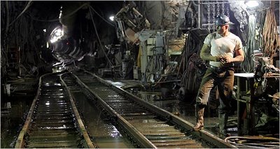
[Image: From the NYTimes – though I now can't find the article].

On the other hand, here is the geometry of war:
    The mathematicians of the Renaissance applied their geometry to all manner of practical disciplines – from navigation and surveying to cartography and perspective. They aimed to demonstrate the usefulness of geometry as well as its ingenuity and certainty, and to associate it with action, achievement and progress. Many new instruments were designed in this context, as the collections of this museum amply demonstrate.
[Image: "A system of fortification and its protagonist." Courtesy of the Museum of the History of Science, Oxford].
    Developments in the art of warfare in the late 15th and 16th centuries provided another outlet for geometry, and the mathematicians were quick to respond by devising techniques, designing instruments and writing books. Heavy guns manufactured in single metal castings were longer, capable of more accurate fire, and were adjustable in elevation. Consequently, gunners needed instruments to measure both the inclination of the barrel and the distance to the target, together with a means of relating these two measurements. Geometers offered a variety of solutions to these problems, as well as designs for fortifications to withstand attack from the new artillery.
Emphasis mine. Here is a list of images – but don't miss the elevated fortress or this spiky precursor to the Pentagon.

[Image: A geometrical town survey; courtesy Museum of the History of Science. (Via)].

Finally, as this was meant to be a quick list... 1) The earth's volcanoes are singing: "High-powered computers are being used to convert seismic readings from Mount Etna in Sicily and Tungurahua in Ecuador into audible rumbles, roars, beeps, and even piano music. The technique, known as 'sonification', is used to help people detect patterns in complex data." 2) The United States is being genetically en-golf-coursed by "creeping bentgrass," a genetically-modified grass immune to commercial pesticides; it was designed to make golf courses easier to maintain and more lush underfoot. Now it will destroy you. 3) The unexpectedly impressive landscape architecture firm EDAW wants the Los Angeles River to include "a Class I bicycle path in and along the Arroyo Seco Channel between the communities of Highland Park and Cypress Park." EDAW's Gulf Coast Mapping Study is also well worth a look (here's a PDF).

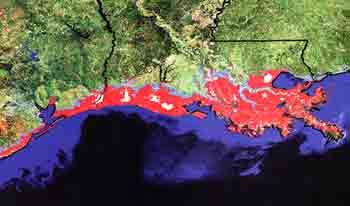
[Image: "The red areas, including New Orleans, lie less than four feet above sea level and could be threatened by storm surges, flooding , and rising sea levels." Courtesy EDAW].

4) This is great – Dennis Dollens uses "Bio-observation and Software Growth as an approach to conceptualize and demonstrate growing architectural elements such as canopies and columns." Via WorldChanging. 5) This is ridiculous.

(Earlier: Quick list 1).

The endgame, the absent, the void

For a variety of reasons, I found myself re-reading an interview I published on Archinect a few months ago with photographer David Maisel – and I really am so enamored with Maisel's work, and so interested in almost everything he has to say, that I thought I'd just post a quick reminder here for anyone who may have missed the interview when it first went up. At the very least, the images are stunning – but Maisel himself is also a thoughtful, funny, remarkably perceptive guy, so the interview itself, I think, justifies a second look.
Here, then, are some teasers, including images and quoted excerpts. If your interest is piqued: here's the actual interview.

9823-4[Image: David Maisel, from The Lake Project].

Maisel is perhaps best-known for his aerial photographs of Owens Lake, California. As cinephiles will no doubt remember, Owens Lake was drained in the early 20th century to water the lawns of suburban Los Angeles (a notorious act of hydrological theft that found its way into American mythology through Roman Polanski's film Chinatown). Owens Lake is now a Dantean wasteland, one of the most toxic sites in North America:
    The only moving things are the dust devils that coalesce and spin in the afternoon heat, swirling white towers of cadmium, arsenic, sulfur, chlorine, iron, calcium, nickel, potassium, aluminum, chlorine. The lakebed emits 300,000 tons of such matter every year; thirty tons of it arsenic, nine tons of it cadmium. We had dreamed of building cities, fields of glittering towers, urban fantasies meant to house our hopes of progress; now we seek out dismantled landscapes, abandoned, collapsing on themselves. Rather than creating the next utopia, we uncover the vestiges of failed attempts, the evidence of obliteration.
9277-1[Image: David Maisel, from The Lake Project].

From the interview:
    "For the most part, I’m interested in landscape images not merely for what they look like, but for what they make us feel, and for what they might represent metaphorically. I’ve also wanted my pictures to take the viewer to places and sites they’ve never seen before, with a resulting sense of alienation or displacement. I'm less interested in being warm and fuzzy than in being harsh and cruel! [laughter] Those possibilities don’t exist when looking at the familiar."
Elsewhere in the interview, Maisel explains how he is interested "in extreme scale, in boundlessness and formlessness, in desolation and landscapes of ruin." In the process, he uses photography to expose "the undoing of things, the endgame, the absent, the void. I’m drawn to aspects of the sublime, and to a certain kind of visceral horror, and in a sense I am using my landscape imagery in order to get to that feeling, as much or even more than I am documenting a specific open-pit mine or cyanide leaching field or clear-cut forest. And I’ll readily admit that my work may not hold up very well from a documentary standpoint."

9821-119828-12[Images: David Maisel, from The Lake Project].

The rest of our conversation covers Californian hydropolitics, the line between architecture and photography, "replicant" landscapes, the dusty fate of human remains, Iceland, The Drowned World by J.G. Ballard, Mars rovers, 9/11, and the aesthetic power of sterility.

(Note: To read more about Ballard's The Drowned World, see BLDGBLOG's first post of 2006: Silt).

Wednesday, August 9, 2006

The Visionary State: An Interview with Erik Davis

[Image: Philip K. Dick's former apartment complex, Fullerton, CA; photo ©Michael Rauner].

In The Visionary State, published last month by Chronicle Books, Erik Davis and Michael Rauner explore the religious landscape of California. The state's cultural topography, Davis tells us, mirrors the physical terrain, "an overlapping set of diverse ecosystems, hanging, and sometimes quaking, on the literal edge of the West":
    This landscape ranges from pagan forests to ascetic deserts to the shifting shores of a watery void. It includes dizzying heights and terrible lows, and great urban zones of human construction. Even in its city life, California insists that there are more ways than one, with its major urban cultures roughly divided between the San Francisco Bay Area and greater Los Angeles. Indeed, Northern and Southern California are considered by some to be so different as to effectively constitute different states. But that is a mistake. California is not two: it is bipolar.
Indeed, the state is animated from below with "titanic forces implied by its geology," Davis writes, and a "frontier strand of nature mysticism" long ago took conscious root.

[Image: The labyrinth in Sibley Volcanic Regional Preserve, Oakland; photo ©Michael Rauner].

Over the course of the book, the authors visit California's "Buddha towns" and Vedantic ashrams, its National Parks and the properties of discontented theosophists. They try to fathom what strange mutations of 21st-century Christianity could produce Jesus, the "OC Superstar," in whose name compassionate self-sacrifice and divine generosity have been reduced to a grinning statue rather pleased with itself in a well-watered grove of palm trees. They even stop by California's hot springs, wineries, observatories, and mind labs – without forgetting the dark side of the state, where Charles Manson, "trippy folk songs," and a psychedelic obsession with "the Now" all meet.
At one point Davis hilariously describes Anton LaVey, author of The Satanic Bible:
    Born Howard Levey in 1930, LaVey was less a freak guru than a Playboy-era steak-and-martini man. He hated hippies and LSD, played Wurlitzer organs in strip clubs, and had no interest in mystically dissolving the ego. Though essentially a con man, LaVey had enough psychological frankness and sleazy charm to attract scores to the black masses he held at his house in the Outer Richmond, a place he had, as the song goes, painted black.
Meanwhile, fans of Blade Runner will be pleased to hear that Davis and Rauner visit the so-called Bradbury Building. There, in Ridley Scott's film, lived J.F. Sebastian, abandoned by everyone and prematurely old, designing his robotic toys.

[Image: The Bradbury Building, Los Angeles; designed by George Wyman, the interior of the building "shoots upward toward a gabled canopy of glass, a lattice of light suspended over the delicate wrought-iron trusses that float in the clerestory haze." Photo ©Michael Rauner].

Though I found the book philosophically adventurous, strangely good-humored, and particularly well-photographed, I will add that my own sense of the sacred – if I can phrase it as such – felt constantly challenged throughout. In other words, almost every time the authors visited a new site, I found myself immediately engaged in a kind of comparative landscape theology, asking: why is this place sacred?
Why on earth would they go there?
After all, is an archaeological site sacred to the Chumash more sacred than a street sacred to Philip K. Dick – or a quarry sacred to the Center for Land Use Interpretation? Or vice versa? What about a site favored by Erik Davis and Michael Rauner themselves, as they performed literally years of research for the book?
Such questions only lead to more of themselves. If the Mormons, for instance, launched a geostationary satellite over the city of Los Angeles, and they used it to broadcast radio sermons, is that precise location in the sky – a square-meter of rarefied air – to be considered sacred? Or is there a holy tide or blessed current that flows through the coves of Big Sur – whose landscape, a "wild harmony of impermanence and beauty," Davis writes, so stunned the poet Robinson Jeffers? Does that visionary landscape have a correspondingly sacred hydroscape, some undersea world of the dead discussed a thousand years earlier in tribal myths? Can the weather be sacred – or even a particular storm?
And where does the geography of celebrity fit in...?
How do you differentiate between the sacred and the postmodern – and even outright kitsch?

• • •

I decided the best thing to do was talk to Davis himself – and so I called him. What follows is a transcript of the conversation.

[Images: Swami's in Encinitas; a room in the Star Center, Unarius Academy of Science, El Cajon; and the Temple Room at Goddess Temple, Boulder Creek. Photos ©Michael Rauner].

BLDGBLOG: What were your criteria for deciding if a location – a building, a landscape, a particular street in Los Angeles – was sacred or visionary? Was your list of sites determined by rigorous historical and anthropological research, or by your own subjective interpretation of the sites?

Erik Davis: It was pretty clear, in an objective sense, where the major points were – the major locations to find. I was looking either for a new religious movement that had some literally visionary quality behind it, or for a novel, visionary development within an older and existing tradition. But there was always a grey area. On that level, I started to go a little bit on intuition – not just picking things that I liked, obviously, but picking things that seemed to complete or expand the story behind the book.

A good example is Luna, the tree that Julia Butterfly Hill sat in. Is it religious, is it spiritual, is it visionary? Even from an anthropological perspective, you’re kind of left wondering about that – but I really felt like there was something powerful in the way the tree came to serve as an update for the story of nature mysticism in California. We actually had to work quite a lot to access Luna – because it’s on private land, and they don’t like people to know where it is – but we did finally get there, and we went to the tree, and we thought, you know: it’s an impressive tree, it’s got these weird braces on it that stabilized it from where somebody tried to chop it down... But around the back side of the tree, there was this hollowed-out, blackened hole – and it was full of little trinkets. People had come, sneaking onto the land, in order to pay homage. There was a Navaho dreamcatcher and a little bodhisattva figure and a teacup and a little glyph of a tree – it was this rag-tag mixture of objects that had transformed the tree into a kind of miniature shrine.

I saw that and I thought: okay, I’m on the right track. [laughs]

[Image: Tire Tree, Salvation Mountain, Slab City; photo ©Michael Rauner. This, of course, is not Luna].

BLDGBLOG: At one point, you visit Gary Snyder's zendo, and you mention the Beat Generation in several places throughout the book – but what about visiting a few more locations from the Beats' literary heyday, like the apartment where Allen Ginsberg wrote “Howl”?

Davis: I tried to keep to things that were as explicitly religious or spiritual as possible – but, you can imagine, we had a long B-list of places we thought we could include. We were constantly asking for more space from the publisher! There are just so many elements that went into it: geography; wanting to keep a balance between urban and rural, north and south, different traditions – Buddhist, Christian, pagan, Native American. There were places that were famous vs. places that weren’t famous – this kind of high/low tension – but there were also things that just came out of the earlier sites. People start telling you stuff.

Like at Watts Towers: one of the guys who worked there was a local, and we started talking about assemblage, and collage, and using different pieces of trash to make art – and he said, Oh, you know, there’s this great place called Self Help Graphics out in East L.A., and I never would’ve found that place if I hadn’t met the guy. So Michael Rauner and I went out there, and it was great.

There were all kinds of synchronicities like that.

[Image: The Virgin of Guadalupe, Self Help Graphics & Art, East L.A.; photo ©Michael Rauner].

BLDGBLOG: This is perhaps a question more appropriate for J.G. Ballard than it is for The Visionary State, but were you ever tempted to include things like the site where James Dean was killed? Or the exact route driven by O.J. Simpson as he fled the police? For that matter, what if you'd found out that the whole Los Angeles freeway system had been designed by some rogue Freemason – and so all those knotted flyovers and concretized inner-city access routes are really a huge, psycho-spiritual landscape installation? Something between the Blythe geoglyph and the maze outside Grace Cathedral?

Davis: I would have loved that. [laughter] But, you know, the further you go into these weird mixtures of imagination and space, inevitably that kind of thing comes your way. That’s the thing about psychogeography – because, in a way, what I was doing was a kind of relatively gentle psychogeography of the state.

For instance, one thing I really enjoyed seeing was this witch’s map of California, where she’d laid the 7 chakras down onto different regions of the state – and I really wanted to work that in. But as far as the built, modern, commercial, secular landscape of California goes, if I had come across stuff like that – and I’m sure there’s some of it out there – then of course. That wouldn’t surprise me, for one thing – and it would excite me, for another. As I say, we have a long B-list.

[Image: The Witch House/Spadena House, Beverly Hills; photo ©Michael Rauner].

BLDGBLOG: Finally, where do earthquakes and seismology fit in all this? For some reason, I was expecting the San Andreas Fault to play a much larger role in the book – but you don't really play that up. Which I actually then preferred.

Davis: You're right – I didn’t play that too strongly – but it's definitely there as a kind of psychic twist inside the state. For me, the seismology thing really worked in a more gentle way, and that was by talking about the hot springs. In the hot springs you see how the seismically active underside of California has created an environment where you get natural springs, and those become centers of healing.

When I started out, I thought there were going to be more explicit landscapes to include in the book – like Death Valley, and the San Andreas Fault – but the more we got into it, the more we found there were built structures just screaming out for inclusion. The book ended up shifting subtly toward architecture and the built environment, with the landscape providing the background, as it were, for these more specifically cultural places of spiritual and visionary power.

[Image: Huxley Street, Los Angeles, named after Aldous Huxley. By the end of his life, Davis tells us, Huxley had "concluded that people needed to change on an individual psychological level if civilization was going to avoid the disasters he glimpsed on the horizon: overpopulation, high-tech war, ecological catastrophe, and the sort of narcotized totalitarian propaganda depicted with such lasting power in Brave New World." Photo ©Michael Rauner].

• • •

At the book's end, Davis reconsiders sunset, an event that resets the westward clock to its cyclic eastern origins; it is, he says, "the holiest moment of the day." But sunset is too easily mythologized: it resets no clocks, and its cycles are not human but magnetic, thermochemical, turning on an alien timescale that knows nothing of earthly religion.
In the myths that do arise, however, transforming westward motion into something yet more godly and epic, California plays a distinct – and vulnerable – role:
    In the American imagination, California's shores stage both the fulfillment and decline of the West, its final shot at paradise and its perilous fall into the sea. That is why the California dream encompasses both Arcadian frontier and apocalyptic end zone, Eden and Babylon. As Christopher Isherwood put it, "California is a tragic land – like Palestine, like every promised land."
[Image: Noah Purifoy Sculpture Garden, Joshua Tree; photo ©Michael Rauner].

(Thanks to Erik Davis for his time and enthusiasm, and to Michael Rauner for the fantastic photographs. Meanwhile, Erik will be presenting The Visionary State at a number of locations; here's his schedule of appearances. Tonight, August 9th, for example, Davis will be speaking in Oakland at DIESEL Books. If you go, tell him you heard about it on BLDGBLOG).