Wednesday, August 23, 2006

BLDGBLOG Moves to Los Angeles

Southern_CA_EQ_11x14[Image: USGS Map of southern California earthquakes; huge version also available].

In less than one month, BLDGBLOG will have picked up and moved itself to sunny Los Angeles, land of freeways and plate tectonics, Philip K. Dick and gang warfare, bikinis and Jurassic technology; city of tar pits and the porn industry, Joshua trees and desert gardens, Scientology and cinema – and so on. Mike Davis. The Italian Job. Anonymity and desert apocalypse. Watts Towers.
In any case, if anyone out there reads BLDGBLOG – any advice on where to live, what to do, who to know...? Better yet, are you in the real estate business and you just happen to have the perfect 2-bedroom apartment, with office space, eagerly waiting to be rented in the ideal neighborhood – and it's so secret that even Curbed LA doesn't know about it yet? For that matter, are you preparing to leave the country for several months and you live in Beverly Hills and you need an architecturally enthusiastic man and his delightful wife to water your plants till you get back? And use your pool for you and save the dinner plates from earthquakes...? Or perhaps you are newly stricken with the philanthropy bug, so you want to donate a well-lit room with bookshelves in which BLDGBLOG can upload itself in the off-hours, meditating on Californian socio-spatiality?

[Image: Octopus L.A. For the more satellite-inclined, check out Visible Earth's 3.1MB image of Los Angeles from space. Soon you'll see BLDGBLOG driving around somewhere].

If so – or if you just know a good bar to regularize, or you want to organize deep desert geology hikes, or you want to put together a talk20-like event – leave a comment or be in touch or do neither, but keep reading BLDGBLOG knowing that we'll soon be neighbors.
Until that western arrival comes, posting will continue apace – although you may see a lot more Quick list-style posts as general busy-ness seems to be increasing by the day.

Delta force 2

[Image: One more image, this time of the Netherlands (again, courtesy of NASA's Earth Observatory). "Along the southern coast of the Netherlands," EO explains, "sediment-laden rivers have created a massive delta of islands and waterways in the gaps between the coastal dunes." Also available in a visually-stunning 3.2MB version. Earlier on BLDGBLOG: Delta force].

Tuesday, August 22, 2006

Quick list 3

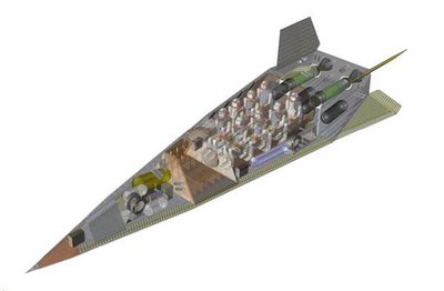
[Image: "PlanetSpace's Silver Dart spacecraft could one day launch space tourists into orbit from a Nova Scotia spaceport and land 45 minutes later in Sydney, Australia." New Scientist Space].

Canada's first spaceport will soon be under construction – privately owned and operated: "The province of Nova Scotia has signed an agreement setting aside 300 acres of government-owned land for US-Canadian private space firm PlanetSpace to construct a rocket launching facility." The company "hopes to develop a space tourism business, ferrying customers into space in suborbital and eventually orbital flights. The first suborbital launch should occur "by late 2008 or early 2009."
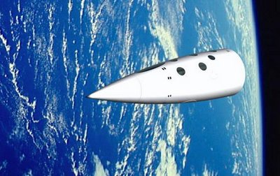
[Image: PlanetSpace's "suborbital crew vehicle." New Scientist Space].

"As for environmental concerns, Geoff Sheerin, CEO of PlanetSpace, says the company has chosen to use ethyl alcohol fuel for its rockets because it is environmentally friendly. 'Our fuel comes from corn,' Sheering told New Scientist. 'Even if it gets in the water, it dissipates very quickly with no damage to the environment. It's a green rocket, so to speak.'"
Speaking of green, you can now unpack a park over at Inhabitat: "It's a mobile trailer that unfolds into an elevated park replete with a fire circle and wildflowers."

[Image: Untitled (Caravan 2) by Kevin van Braak. Via Inhabitat].

I've ordered 149,000 of them. I am starting a fiefdom in the Yucatan.
Meanwhile, "Hollywood-style" security systems are now ready for installation in your very own home; they won't protect you, but they will use eye-catching red lasers meandering back and forth across the room in unpredictable patterns to make your house look really cool (and thus worth breaking into). More here.
Then there's the inadvertant pruning effects of hurricanes Rita and Katrina – or the hurricane as landscape architect: "The Chinese tallow tree is invading the US Gulf coast forests, replacing the region's native hardwoods. The tree's advance is a direct consequence of the ecological disruption caused by hurricanes Rita and Katrina." For a variety of reasons, I was fascinated to read that the tallow tree is "an ornamental species introduced by Benjamin Franklin in 1772." It can "quickly grow to 10 metres and is resilient to many pests." Whoops.
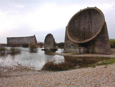
[Image: Sound mirrors, England, from this site].

The Athanasius Kircher Society revisits England's sound mirrors: wartime acoustic reflectors used to amplify the sounds of distant Nazi aircraft. For a bit more on the sadly derelict structures, see earlier on BLDGBLOG – or visit The Sound Mirrors Project.
Your inner earth-catastrophist should be sweating with glee: "More than half of the world's major forests will be lost if global temperatures rise by an average of 3ÂșC or more by the end of the century," the Guardian reports. "Extreme floods, forest fires and droughts will also become more common over the next 200 years as global temperatures rise." That's in addition to the Guardian's earlier prediction that "floods, malaria, shark attacks, sweltering summers and worsening drought" will all become more common. Shark attacks? It seems higher temperatures "will confuse wildlife." The Guardian continues, warning elsewhere that the UK will soon become a "tinderbox" in which whole peatlands may go up in flames, radically accelerating climate change due to the rapid release of stored carbon.
With climate change on the brain, it's never too late to take another look at Land+Living's February 2006 article about sustainable car parks in Los Angeles – including some wonderfully misguided comments at the end. The actual project under question is a proposal for re-landscaping the surface parking lots of L.A., using, for instance, embedded solar power generators and permeable paving.

[Image: From Land+Living].

Finally, the Museum of Ephemerata, in Austin, TX, has released their Illustrated Retrospective of Machines (available as a PDF).

[Image: From Scott Webel's and Jen Hirt's Museum of Ephemerata].

The Retrospective, originally intended as a guide to the Museum's now-closed machines show, gleefully participates in that under-appreciated genre of the guide to temporary collections of objects. Walter Benjamin would be proud.
From the text: "Everywhere around us the Machines clank, whir, and buzz, producing ultra-modern objects alongside archaic effluvia, vast landfills of trash – and vast, trashed landscapes. Inside two centuries, they have infiltrated every social nook and bodily cranny. They service and are serviced... What is this massive force in natural history? Just what are the Machines?" Read further and learn about the Moonlight Towers, Orgone Accumulators and Dreamachines, and even a replica UFO – then drive to Texas and visit the museum in person.
One more thing: speaking of machines, spherical micro-robots may one day explore Mars: "The micro-robots could land on the surface of another planet arranged in a capsule like eggs in a carton. Or they could be dropped onto the planet by a balloon floating above the surface. They would move by rolling and bouncing, powered by artificial muscles that alter their overall shape."

[Image: Spherical micro-robots. From New Scientist Space].

The robots "would each be a few centimetres in diameter, about 100 grams in weight, and would be able to jump about 1.5 metres in a single bound, travelling 50 kilometres over their lifetimes." They would be particularly useful in extraterrestrial spelunking: "the micro-robots could position themselves to enable communications from deep within a cave. Each one would act as a relay, passing messages back to a central unit. Fifty micro-robots lined up in this manner could theoretically explore a cavern a kilometre deep."
We should therefore send them to Titan, one of Saturn's moons – because it "may be riddled with caves... presumably carved out by the methane rain that is thought to fall on Titan."

Friday, August 18, 2006

An Island No More

"Plug up the Hudson river at both ends of Manhattan... divert that body of water into the Harlem river so that it might flow out into the East river and down to the Atlantic ocean... pump out the water from the area of the Hudson which has been dammed off… fill in that space... ultimately connecting the Island of Manhattan with the mainland of New Jersey... and you have the world’s eighth wonder – the reconstruction of Manhattan!"

No, it's not Pruned's Alex Trevi talking in his sleep; it's an old jewel of an urban plan by Norman Sper, re-discovered several months ago by Modern Mechanix.

Sper intended for the Hudson in-fill "to solve New York City’s traffic and housing problems, which are threatening to devour the city’s civilization like a Frankenstein monster" – and this was in 1934.

Manhattan would thus no longer be an island.

But Sper's ideas went "still further. No use waiting, he says, until the entire area is filled in before starting underground improvements. Build your tunnels, conduits, mail and automobile tubes, and other subterranean passages indispensable to comfort in the biggest city in the universe as you go along. Do it in the process of filling the basin left by the drawing off of the water."

Quoting at length:
    "When every possible subterranean necessity had been anticipated and built,” Sper points out, “a secondary fill would bring the level up to within twenty-five feet of the Manhattan street level. Upon this level would rest the foundations and basements of the buildings that would make up the new city above, planned for fresh air, sunshine and beauty. Thus, below the street level would be a subterranean system of streets that would serve a double purpose. All heavy trucking would be confined to it, but primarily it would serve as a great military defense against gas attack in case of war, for in it would be room for practically the entire population of the city. If the Russians had the vision and the courage not only to build huge cities from the ground up, but to practically rebuild an empire, surely America should not be frightened at a project as big as this.”
The rest of the article – available at Modern Mechanix – is hilariously earnest and worth a quick read.

(Via designboom and Coudal).

Thursday, August 17, 2006

Real Estate From Above

[Image: From Real Estate – 100 Aerial Drawings by Heman Chong].

For his project Real Estate – 100 Aerial Drawings, artist Heman Chong "collected satellite pictures of Singapore." He then "traced out" one hundred buildings "from a bird's-eye view" (or satellite's-eye view), mounting the images in red on white to match the colors of Singapore's flag.
The result is architectural form abstracted from its terrestrial setting, turned into nothing but shape. Each image even vaguely resembles some alien craft out of Space Invaders – a game whose title is an apt metaphor for real estate development as such.

[Images: From Real Estate – 100 Aerial Drawings by Heman Chong].

Japanese sound artist Toru Yamanaka then composed five really nice little soundtracks for the project's website; each soundtrack loops after roughly a minute (or so), and the first three, in my opinion, are the best. Melancholic machine-drones and urban noise intersecting.
The buildings range from structural archipelagos scattered across large urban sites –

[Image: From Real Estate – 100 Aerial Drawings by Heman Chong].

– to perfectly Euclidean shapes; some even look like corporate logos –

[Image: From Real Estate – 100 Aerial Drawings by Heman Chong].

– emblazoned on the planet, as if some firm would design their HQ specifically to be viewed by satellite. Future facades, in the age of Google Earth.

(A brief interview with Heman Chong here; and thanks to Melissa for the tip!)

Wednesday, August 16, 2006

Freezone

[Image: freezone, by Stanza. According to the project brief, "each unit allows for peace and quiet inside an information free zone." It's "the holiday destination of the future." You can't be spammed, virused, phoned, emailed, tracked – aside from the fact that your location is rather public – or RFID'd, etc. You could be RPG'd on the other hand... It's secession from the dataworld, via utopian architecture. More projects, including velodrone, where traffic jams "trigger audio visual light displays of generative music." (Spotted at WMMNA)].

Tuesday, August 15, 2006

Quick list 2

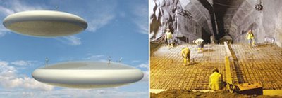
[Images: Raytheon's flying antenna-blimp (via Defense Tech), and an "11.2-kilometer tunnel [being dug] through a mountain more than 2,400 meters high in Central Ecuador"/ENR].

Raytheon is working on "a radar antenna that spans the length of a football field." Even better, it flies: "The airship, remaining essentially motionless, could hover for long periods above the jet stream at altitudes of 65,000 to 70,000 feet, with the antenna transmitting on UHF and X-band."
Going in the opposite direction, a German firm is drilling one of the deepest tunnels in the world – though it is also one of the highest. The tunnel is simultaneously "under more than 900 meters of earth" and "more than 2,400 meters high," passing through the mountains of central Ecuador. As Engineering News-Record reports, the geology is immensely complicated there and the tunnel has already collapsed twice; it is part of a much larger hydroelectric power scheme for the Ecuadorian Andes.
Fascinatingly, to secure loose rubble inside the tunnel – including cracks in the walls and ceiling – the project engineers "inject" the mountain "with resins and foam to consolidate the mass and stabilize it.”
So what new veins of weird geology will Andean hikers stumble upon in a few ten million years...?

[Image: The tunnel's route/ENR].

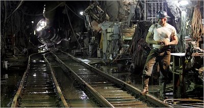
Another tunnel back in the news is NYC's City Tunnel No. 3, explored several months ago on BLDGBLOG, and photographed beautifully by Stanley Greenberg.

[Image: City Tunnel no. 3; photo by Sewell Chan/New York Times].

Meanwhile, Japan is working on a 30-year weather forecast via the Earth Simulator – not an Amsterdam-based performance artist but one of the world's fastest supercomputers. The Earth Simulator "occupies a warehouse the size of four tennis courts in Tokyo," and scientists want to use it "to map the routes taken by typhoons, heatwaves and droughts, and potentially spare millions from death and disease."
Then there's this near-perfectly arranged photograph – of GWB speaking on an empty airport tarmac – which rewards sustained analysis. The transnationally geometric infrastructure of power:

[Image: From the NYTimes – though I now can't find the article].
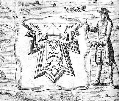
On the other hand, here is the geometry of war:
    The mathematicians of the Renaissance applied their geometry to all manner of practical disciplines – from navigation and surveying to cartography and perspective. They aimed to demonstrate the usefulness of geometry as well as its ingenuity and certainty, and to associate it with action, achievement and progress. Many new instruments were designed in this context, as the collections of this museum amply demonstrate.
[Image: "A system of fortification and its protagonist." Courtesy of the Museum of the History of Science, Oxford].
    Developments in the art of warfare in the late 15th and 16th centuries provided another outlet for geometry, and the mathematicians were quick to respond by devising techniques, designing instruments and writing books. Heavy guns manufactured in single metal castings were longer, capable of more accurate fire, and were adjustable in elevation. Consequently, gunners needed instruments to measure both the inclination of the barrel and the distance to the target, together with a means of relating these two measurements. Geometers offered a variety of solutions to these problems, as well as designs for fortifications to withstand attack from the new artillery.
Emphasis mine. Here is a list of images – but don't miss the elevated fortress or this spiky precursor to the Pentagon.

[Image: A geometrical town survey; courtesy Museum of the History of Science. (Via)].

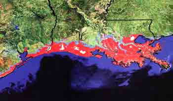
Finally, as this was meant to be a quick list... 1) The earth's volcanoes are singing: "High-powered computers are being used to convert seismic readings from Mount Etna in Sicily and Tungurahua in Ecuador into audible rumbles, roars, beeps, and even piano music. The technique, known as 'sonification', is used to help people detect patterns in complex data." 2) The United States is being genetically en-golf-coursed by "creeping bentgrass," a genetically-modified grass immune to commercial pesticides; it was designed to make golf courses easier to maintain and more lush underfoot. Now it will destroy you. 3) The unexpectedly impressive landscape architecture firm EDAW wants the Los Angeles River to include "a Class I bicycle path in and along the Arroyo Seco Channel between the communities of Highland Park and Cypress Park." EDAW's Gulf Coast Mapping Study is also well worth a look (here's a PDF).

[Image: "The red areas, including New Orleans, lie less than four feet above sea level and could be threatened by storm surges, flooding , and rising sea levels." Courtesy EDAW].

4) This is great – Dennis Dollens uses "Bio-observation and Software Growth as an approach to conceptualize and demonstrate growing architectural elements such as canopies and columns." Via WorldChanging. 5) This is ridiculous.

(Earlier: Quick list 1).